Projects
Current projects
 Funding: Helmholtz Innovation Pool
Project term: 2025-2027
EXTREME-ADAPT: Quantifying the effect of adaptation measures on spatiotemporal changes in flood and drought risk
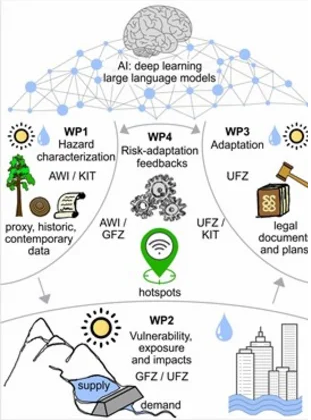
EXTREME-ADAPT addresses the increasing impacts of hydrological extremes, such as floods and droughts, by investigating their driving factors: hazard, exposure, vulnerability, and adaptation. Focusing on the Central European river basins (e.g., Danube, Rhine, Elbe, Weser, Oder), the project employs a dual temporal perspective—spanning 500 years of historical data and contemporary records since 1990.
The project integrates paleoclimate indicators and hydroclimatic data to identify hazard hotspots. Using Bayesian networks and in-house datasets, we will explore causal dependencies between hazard, exposure, vulnerability, and impacts in these key hotspot areas. This will provide information on the main contemporary drivers of change in impacts. Leveraging the unprecedented abundance of digital texts (e.g., climate adaptation plans) and cutting-edge large language models, we will collect evidence on implemented adaptation measures. Finally, interpretable machine learning tools and qualitative analyses will be used to assess the effect of adaptation measures on risk reduction. Results will provide a step-change in the assessment of risk generation processes and their temporal changes. This will enable us to disentangle complex interactions between risk drivers and the implemented adaptation measures, generating a new basis for analyzing their effectiveness.
Collaboration among four Helmholtz Centers ensures interdisciplinary excellence. EXTREME-ADAPT innovative approach lies in integrating several data-driven AI tools and benchmark datasets developed at UFZ, GFZ, AWI, and KIT.
Team:
- UFZ: Mariana Madruga de Brito (lead), Dr. Larisa Tarasova , Jan Sodoge, Sungju Han, Daniela Peña Guerrero
- GFZ: Heidi Kreibich, Danijel Schorlemmer, Kristina Koronaci
- AWI: Monica Ionita, Viorica Nagavciuc
- KIT: Uwe Ehret
Web: https://earthenvironment.helmholtz.de/changing-earth/innopool-projects/
Funding: Helmholtz-Gemeinschaft Deutscher Forschungszentren (HGF)
Project term: 2026 - 2028
Securing Terrestrial Water Cycles: the Helmholtz SOlution Lab Elbe RiVEr Basin (SOLVE)
A central element of the initiative are three so-called Solution Labs, in which concrete, practical solutions are developed. The SOLVE Solution Lab focuses on integrated strategies for entire catchment areas, using the Elbe River as an example. Previously fragmented data and measures are brought together with the aim of developing practical and applicable solutions at the level of water catchment areas that contribute to the protection of people and the environment through the systematic optimisation of water management. In addition to concrete measures designed to retain water in the landscape, the Water Action Hub establishes a forum for dialogue in which stakeholders and scientists can exchange ideas on the topic of water area management in the long term.
Contact
Spokesperson:
Prof. Dr. Ralf Merz
Coordination:
Daniela Peña Guerrero
 Funding: Deutsche Forschungsgemeinschaft (DFG)
Project term: 2026 - 2029
Hydrometric and isotopic event SIGNatures to evaluate functional resilience of diverse hydrological Systems to global change (HydroSIGNS)
Project description
Advancing global climate and land use change particularly threatens vulnerable hydrological systems with low functional resilience. Such resilience is defined by two components: the ability of systems to withstand change and to buffer extremes. However, it is still unclear where the global hotspots of low and high functional resilience are located. Isotopic signatures that reflect the origins and residence times of water in springs and streams is the most reliable indicator for detecting such hotspots. However, the required stable water isotope measurements are still scarce globally, especially for springs that are particularly susceptible to global change. Instead, hydrometric event-based signatures can be obtained from streamflow and precipitation time series available for many locations worldwide. However, it is still unclear where and when, i.e., in which types of hydrological systems, and under which event conditions the isotopic signatures can be inferred from hydrometric signatures and which hydrometric signatures are the most suitable for such inference. The aim of the project is to quantify functional resilience (i.e., the ability to withstand change and buffer hydroclimatic and environmental extremes) of hydrological systems across spatial scales worldwide by means of hydrometric event signatures most closely capturing water origins. As part of the project, we will derive hydrometric event-based signatures for a wide set of global river catchments and karstic springs, which are known for their quick reactions on climatic changes and extremes. These signatures will be rigorously tested and improved using the collated datasets of stable water isotopes and the results of own isotope measurements that will be conducted as part of the project. Once tested, these signatures will be used to perform the analysis of functional resilience of hydrological systems along the subsurface heterogeneity gradient (e.g., from very heterogeneous systems, like springsheds of karstic springs, to small watersheds with heterogeneous subsurface structure and to larger river catchments), which might be associated with contrasting levels of vulnerability. The ultimate objective of this project is to develop a novel process-based model-independent method for evaluating sensitivity of hydrological systems to global change and exacerbating extremes applicable at the global scale. This will help to identify regions where hydrological systems might fail to provide ecosystem and societal services in the future and support development of target adaptation measures for such regions. Moreover, this project will help to bridge the gap between large sample hydrology and critical zone communities and to obtain reliable process-based insights on functional resilience of different hydrological systems to the ongoing global change worldwide.
Applicants:
Prof. Dr. Andreas Hartmann • Dresden TU, Chair of Groundwater Systems
Dr. Larisa Tarasova
UFZ
 Funding: Societal and Environmental impacts of complex ExtremeS in A changing World -- UFZ PhD Cohort
Project term: 2025-2028
SEESAW - Societal and Environmental impacts of complex ExtremeS in a chAnging World
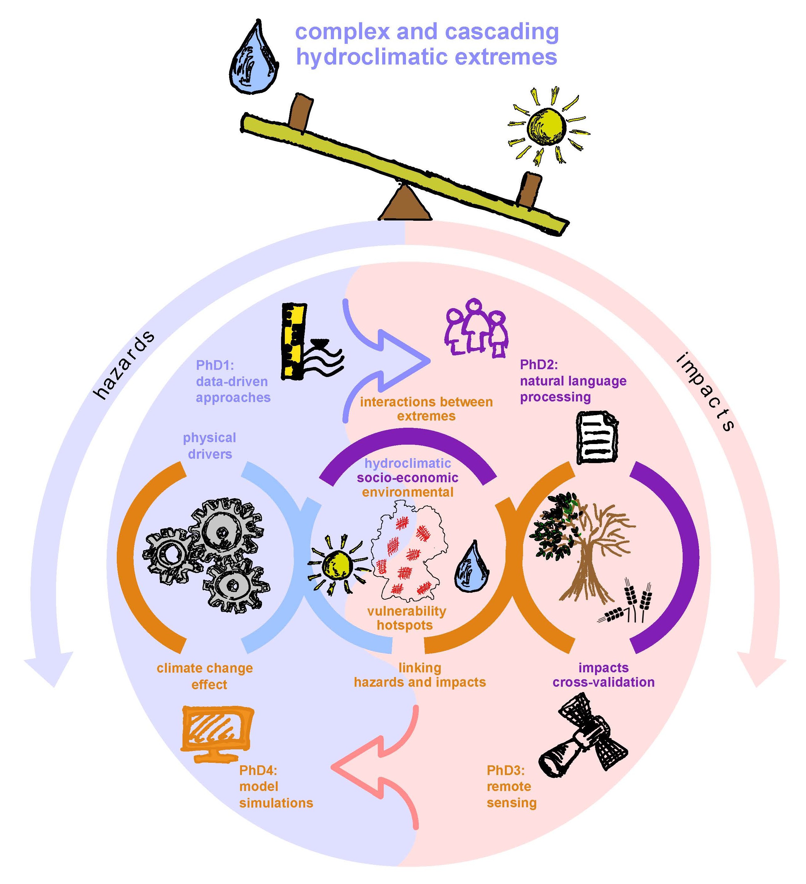
The SEESAW PhD cohort aims to understand the non-linear relation between complex hydroclimatic hazards, their socioeconomic and environmental impacts, as well as the climate change effect on such impactful events. For this purpose, we will use long-term hydrometeorological observations and process-based statistics, unprecedented newspaper dataset and large language models, AI-powered remote sensing and counterfactual climate model simulations. The activities of the cohort will help to identify vulnerability hotspots at national scale to support targeted adaptation measures.
SEESAW concept:
- Considering complex extremes: collation, development and cross-validation of long-term multi-source monitoring products
- Linking hazards and impacts: understanding complex landscape and socio-economical feedback
- Disentangling climate change effect: novel counterfactual simulations of complex extremes
Coordinator:
Dr. Larisa Tarasova
Completed projects
 Funding: Funded by Deutsche Forschungsgemeinschaft (DFG)
Project term: 2019 to 2023
Propensity of rivers to extreme floods: climate-landscape controls and early detection (PREDICTED)
Project description
The occurrence around the world of several major river floods in a short period of time, pictured by sharp upward deviations (called step changes) of the curves used to assess how large floods can be and how often they will occur (called flood frequency curves), recently led citizens, engineers and scientists to wonder whether floods have changed. This is an important issue for social endeavors and economic sectors which require trustworthy evaluations of the flooding hazard of river basins, such as urban planning, the management of water resources and the insurance industry. Alterations of the climate and loss of soil storage due to human activities (e.g. intensive agriculture and urbanization) are often claimed to trigger these phenomena. However, the normal functioning of river basins might also cause floods that appear as extreme because they were not yet recorded in the available data series. The project aims to ascertain whether the interactions between climate and landscape of river basins are able to produce extreme floods, also when no changes of the external drivers (e.g. rainfall) occur. Moreover, it aims to provide handy methods to assess this possibility based on features that can be characterized also in areas where extreme events have not been observed yet and long records of floods are not available. Methods to detect in an objective way the beginning of distinct rises of observed and modeled flood frequency curves (i.e. the position of step changes) will be developed. After verifying that step changes may be more than mere mathematical fakes due to the limited length of the available data, and that modifications of rainfall or land use are not necessarily required for having step changes, attributes of river basins linked to their appearance will be investigated. The focus will be placed on climatic and landscape features that have been suggested as relevant for streamflow generation by a recently proposed simplified description of the processes taking place within river basins. An index which summarizes how these features interact to produce (or not) step changes will be derived. The capability of this index to predict the position of the step change will be tested against observations in a large set of river basins from different geographical regions. The possibility to adopt the step change as a divide between normal and extreme floods will be evaluated as well. The ultimate objective of this project is the development of charts describing the reliability of observed time series for assessing flood hazard in river basins subject to different climatic and landscape settings, or the required length of monitoring to obtain trustworthy estimates of floods. Modifications to these indications of practical interest recommended as a consequence of climate change will be also provided by means of scenarios.
Participating persons: Dr. Stefano Basso • Dr. Larisa Tarasova • Prof. Dr. Ralf Merz • Prof. Dr.-Ing. Gianluca Botter
 Funding: Funded by Deutsche Forschungsgemeinschaft (DFG)
Project term: 2017 to 2024
Space-Time Dynamics of Extreme Floods (SPATE)
Sub Project: Flood types - controls in a changing world (TP 4)
Project description
The event classification developed during the first funding period enables sorting the plethora of different rainfall-runoff events into typical representatives, with a clear description of similarities and differences in triggering mechanisms and event characteristics. The classification allows us to identify and compare only those events stemming from similar processes, and gives insight into the spatio-temporal changes of differing flood producing factors. In the first phase of the project, causative types of runoff events have been defined from a hydrological perspective by considering patterns of rainfall and snowmelt events within each catchment, coinciding catchment state and routing effects. In the second phase in collaboration with SP 2 we will decipher the links between the occurrence of event types and atmospheric drivers, such as blocking conditions, cyclone tracks, circulation patterns and long-term climatic variability, to understand the causative chain of event type occurrence. To account for expected increasing water holding capacity of the atmosphere and hence increasing importance of extreme rainfall events, we will extend the validity of the event typology developed in PH1 beyond mesoscale catchments by considering space-time dynamics of rainfall events at finer temporal resolution in small catchments. Together with SP 3, we will also account for routing effects in large catchments using a coupled hydrological-hydraulic modeling approach , as possible changes in river routing due to river training are expected to change future flood behavior as well. While the first phase has focused on past changes of event types in space and time, in the second phase we will analyse the drivers of change and we will tackle the question of how the occurrence of event types will possibly change in the future if, e.g., climatic conditions, such as the frequency of rainfall events with high intensities, will change. The analysis of the future evolution of event types will be based on scenarios using the classification scheme developed in the first period driven by modelled inputs provided by SP2. Finally, we will shed light on the ability of state-of-the-art conceptual hydrological models to represent streamflow dynamics of specific event types. This will provide valuable information on the reliability and uncertainty of model-based predictions of future floods.
Participating persons: Prof. Dr. Ralf Merz
 Funded by: Helmholtz Centre for Environmental Research - UFZ PhD college
Project term: 2020-2023
DYNAMO – Events as DYNAmic drivers of pollutant transport, turnover and export in catchments – from monitoring to MOdels
The second PhD college of the Thematic Area Water Resources and Environment
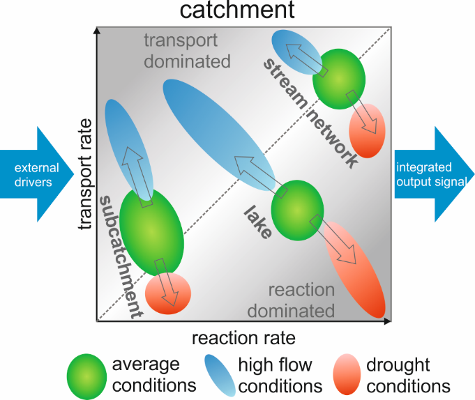
Managing our freshwater resources to mitigate adverse effects of diffuse pollution, for example, by nutrients or agrochemicals is a challenging problem. To develop robust management strategies for water quality, it is imperative to understand the key drivers that control transport and turnover of these pollutants and their subsequent export. Catchments are complex, dynamic systems consisting of interconnected compartments, such as the unsaturated zone, groundwater, lakes and the river network, which transport, process (e.g. by reactive turnover) and eventually export pollutant inputs from diffuse and point sources. These compartments can be conceptualized as a sequence of reactors, each characterized by distinct transport and reaction rates (see figure below), which exchange water and solutes to produce an integrated pollutant output signal at the catchment outlet.
Compartmental transport and reaction rates are driven by the dynamics of hydro-meteorological events. The frequency and sequence of hydrological events, in particular extreme events such as heavy rainfall, floods, droughts or heat waves have a major, often long-lasting, impact on pollutant export. Recent hydrological extreme events such as the national-scale drought in 2018 or the Elbe flood in 2013 and future changes in event frequency call for concepts and tools to address the impact of such high-magnitude events on pollutant turnover and export at catchment-scale. In view of the increase in the frequency and intensity of extreme events associated with climate change, it is vital to understand how sequences of extreme events alter or disrupt seasonal and long-term patterns of reaction and transport time scales and the corresponding output signals.
PhD 1: Deciphering catchment's transit time dynamics using event isotope signatures
Advisory team: Prof. Dr. Kay Knöller , Dr. Stefanie Lutz, Dr. Paolo Benettin, Prof. Dr. Ralf Merz
PhD 3: Effects of hydrological events on solute mobilization and delivery in German river catchments
Advisory team: Dr. Larisa Tarasova , Dr. Andreas Musolff, Dr. Jana von Freyberg, Prof. Dr. Ralf Merz
 Funding: Funded by EU Horizon 2020 Innovative Training Network
Project term: 2016 - 2020
Managing soil and groundwater impacts from agriculture for sustainable intensification
Agricultural production in Europe has significantly damaged soil and water resources, ecosystem biodiversity, socio-economic well-being and contributed to climate change. Expected further intensification of production to ensure food safety for population growth must be sustainable to minimise future impacts and negative externalities. This ETN addresses these challenges by training 15 early stage researchers in cutting edge research skills and innovative approaches to manage soil and groundwater impacts from agriculture for sustainable intensification. It supports EU policy goals on food security, resource conservation, renewable energy and climate change, and the aims of the H2020 Societal Challenge 5 Work Programme for sustainable management of the environment and its resources. The scientific objectives focus on developing (1) management techniques which mitigate environmental impacts of agricultural practices on soil, water and climate systems, and support sustainable intensification using new production methods; (2) ""smart"" environmental monitoring, biotechnology and modelling tools to predict the outcome of measures and practices in (1); (3) decision-making tools with sustainability indicators to implement sustainable agricultural production methods. This will be achieved by linking lab-scale studies of processes with field-scale evaluation of novel management concepts, analytical tools and modelling, using state-of-the-art methods. The network includes research, advisory and commercial organisations from all sectors of the agri-environmental management community, and SMEs to multinational firms. Its novel training agenda of workshops and summer schools on technical and business skills, international conferences, industry secondments and knowledge transfer activities has the specific aim of transferable skills training. This is highly relevant for scientific communication, societal impact and entrepreneurship, preparing the fellows for careers in many sectors.
Contact: Prof. Dr. Kay Knöller
 Funding: HGF - Helmholtz Association of German Research Centres, Virtual Institute
Project term: 2012 - 2027
DESERVE | The Virtual Institute DEad SEa Research VEnue
This observatory, our most recent addition, is embedded in the Virtual Helmholtz Institute (VI) DESERVE. It explores Earth system processes under the unique conditions of the Dead Sea area in a joint endeavour by the Helmholtz Centres KIT, GFZ and UFZ and their Middle East partners. DESERVE explores an environmentally unique region on Earth addressing three grand challenges: environmental risk, water availability, and climate change by combining long-term monitoring of geophysical parameters (stations are identical to IPOC), studies of coupled processes in the atmosphere, hydrosphere, pedosphere, and lithosphere as well as models for prediction and remediation strategies of geogenic risks.
Contacts: Dr. Christian Siebert , Prof. Dr. Ralf Merz
Web: https://www.gfz.de/en/section/geophysics/section/geophysical-imaging/projects/past-projects/deserve
Cooperations
- Hebrew University Jerusalem, Israel (Amotz Agnon)
- An-Najah University, Nablus, Palestine (Jalal Dabeek)
- Ministry of Energy and Mineral Resources, Amman, Jordan (Ali Sawarieh)
 Funding: Funded bei EU
Project term: 2016 - 2018
MASSTWIN – Spreading excellence and widening participation in support of mass spectrometry and related techniques in Health, the Environment, and Food Analysis
The Department of Environmental Sciences at Jožef Stefan Institute has invested in new state-of-the-the-art mass spectrometry instrumentation and related laboratory infrastructure, an important and essential technique in modern science, but must now bolster its knowledge capacity and raise its research profile through taking practical steps in training and knowledge transfer and networking activities. The project has been designed to further stimulate cooperation and develop long-term strategic partnerships with five research institutes of excellence from five different European countries by establishing a community of practice in advanced mass spectrometric and related techniques applied to three trans-disciplinary thematic pillars: Environment, Health and Food with focus on organic contaminants, element speciation, traditional and non-traditional stable isotopes, nanoparticles and food safety, traceability and authenticity. MASSTWIN has planned management visits, short-term and long-term exchanges of early-stage and senior researchers, thematic scientific workshops/meetings, common working groups and trainings, participation at conferences, trade fairs and open days. MASSTWIN has also been aligned with the objectives of the national Smart Specialization Strategy with an aim to increase science and technology capacity of the JSI-O2. Extensive dissemination/exploitation/communication activities will be aligned with the existing ERAChair ISOFOOD project for Isotope Techniques in Food Quality, Safety and Traceability, coordinated by JSI-O2. The MASSTWIN Users group will consist of representatives of higher education, the JSI Technology Transfer Centre, industry, governmental bodies, NGO’s, and wider community through outreach activities and will therefore account for a positive impact not only on involved personnel and their knowledge, but also on institute level and create positive societal and economical impacts.
Contact: Prof. Dr. Kay Knöller
Other completed Projects:
- GLOBAQUA
Managing the effects of multiple stressors on aquatic ecosystems under water scarcity
(European Union’s Seventh Programme for research, technological development and demonstration) - GlaSCA
Water Availability in Central Asia – Societal Vulnerability to Changing Glacier and Snowmelt Runoff Contributions to Central Asian Rivers
(International Bureau on behalf of the German Federal Ministry for Education and Research) - IATI-SGD
Submarine Groundwater Discharge: Adaption of an autonomous aquatic vehicle for robotic measurements, sampling and monitoring
(Joint project between the two Helmholtz centres GEOMAR and UFZ)
Projects in cooperation

TERENO
Terrestrial environmental observatories
(Tereno is supported by the following Helmholtz Research Centers: Forschungszentrum Jülich - FZJ, Helmholtz Zentrum für Umweltforschung - UFZ, Karlsruhe Institut für Technologie - KIT, Deutsches Zentrum für Luft- und Raumfahrt - DLR, Deutsches Geoforschungszentrum - GFZ)